
搜索结果: 1-15 共查到“农学 the Earth”相关记录19条 . 查询时间(0.031 秒)
The Global Ecosystem Dynamics Investigation: High-resolution laser ranging of the Earth’s forests and topography
lidar ecosystem structure GEDI biomass
2024/1/22
Obtaining accurate and widespread measurements of the vertical structure of the Earth’s forests has been a long-sought goal for the ecological community. Such observations are critical for accurately ...
Analysis of Regional Distribution of Tree Species Using Multi-Seasonal Sentinel-1&2 Imagery within Google Earth Engine
multisensor tree species large areas cloud-computing machine learning
2023/12/6
Accurate information on tree species is in high demand for forestry management and further investigations on biodiversity and environmental monitoring. Over regional or large areas, distinguishing tre...
Forest regeneration within Earth system models: current process representations and ways forward
arth system models forestregeneration reproductive allocation treerecruitment vegetation demographic models vegetation dynamics
2023/11/30
Earth system models must predict forest responses to global change in order to simulate future global climate, hydrology, and ecosystem dynamics. These models are increasingly adopting vegetation demo...
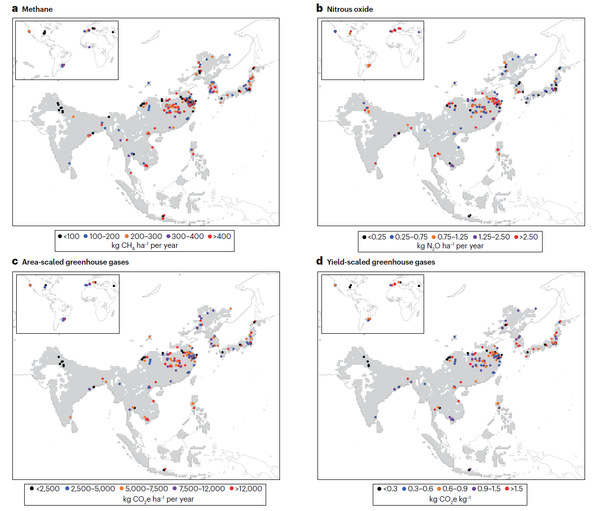
南京农业大学农学院《Nature Reviews Earth & Environment》发表水稻栽培团队“Greenhouse gas emissions and mitigation in rice agriculture”(图)
水稻栽培 数据推测
2023/10/28
2023年9月27日,南京农业大学农学院水稻栽培团队应邀在Nature Reviews系列刊物Nature Reviews Earth & Environment(影响因子42.1)上发表了题为“Greenhouse gas emissions and mitigation in rice agriculture”的综述文章,系统梳理和综述了稻田温室气体排放特征、驱动因子和减排策略。

南京农业大学农学院《Nature Reviews Earth & Environment》水稻栽培团队发文阐述稻田温室气体排放特征、驱动因子和减排策略(图)
水稻栽培 气体排放 因子 减排策略
2023/10/28
2023年9月27日,南京农业大学水稻栽培团队应邀在Nature Reviews系列刊物Nature Reviews Earth & Environment(影响因子42.1)上发表了题为“Greenhouse gas emissions and mitigation in rice agriculture”的综述文章,系统梳理和综述了稻田温室气体排放特征、驱动因子和减排策略。
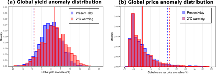
小麦是一种起源于温带的喜凉作物,是全球三大谷物之一,每年提供了全球人口20%的蛋白质和卡路里。目前气候变化的小麦影响评估研究主要集中于研究气候平均态的变化对小麦产量的影响和模型不确定性上。但产量仅是粮食安全问题的一个方面,国际农业贸易也是全球众多国家保持粮食供给的重要手段。因此粮食安全的其它维度(如,农产品价格、农业相关的社会经济与民生问题)同等重要,但相关研究非常有限。
为探明大湄公河次区域植被净初级生产力(NPP)时空变化特征,基于GoogleEarthEngine(GEE)云计算平台,利用MOD17A3HGFNPP时序数据,采用线性趋势分析方法,分析了2001―2019年大湄公河次区域植被NPP的时空变化特征。结果显示:(1)2001―2019年间大湄公河次区域植被NPP总体较高,植被NPP年均值整体上变化趋势不显著,变化波动较大,且与年均温度有显著的负相关性...
西北农林科技大学资源环境学院何海龙副教授在《Earth-Science Reviews》发表最新研究成果
西北农林科技大学资源环境学院 何海龙 Earth-Science Reviews 土壤 水热特征
2020/11/11
近日,西北农林科技大学资源环境学院何海龙副教授在《Earth-Science Reviews》期刊发表了题为“Room for improvement: A review and evaluation of 24 soil thermal conductivity parameterization schemes commonly used in land-surface, hydrologica...
扬州大学园艺与植物保护学院罗云建副教授在《Earth System Science Data》发表综述论文
扬州大学园艺与植物保护学院 罗云建 副教授 Earth System Science Data 林木生物量模型
2020/3/11
近日,园艺与植物保护学院罗云建副教授在《Earth System Science Data》发表题为《A review of biomass equations for China's tree species》的综述论文。论文全面系统地总结了我国1978年至2013年林木生物量模型的研究成果,首次构建了我国林木生物量模型标准库,对于区域森林碳收支核算及林学基础研究具有重要科学价值。
Google Earth在森林防火信息管理中的实现方法
Google Earth 森林防火信息管理 实现方法
2011/8/26
为了提高森林防火信息管理中空间数据的利用效率,针对Google Earth的共享遥感影像数据,提出利用Google Earth的二次开发,将其应用到森林防火信息管理。笔者通过调用Google Earth类库的方法,开发实现了森林防火信息系统。系统读取Access数据库的坐标信息,自动生成并加载各类地标文件,实现防火专题信息定位、GPS跟踪、历史火场位置重现等功能,为森林防火管理与决策提供依据。
Effects of Antibiotics, Zinc Oxide or a Rare Earth Mineral-Yeast Product on Performance, Nutrient Digestibility and Serum Parameters in Weanling Pigs
Piglets Zinc Rare Earth Mineral-yeast Performance Digestibility Serum Parameters
2016/5/5
Two experiments were conducted to compare the effects of feeding a newly-developed rare earth mineral-yeast product, zinc oxide (ZnO) or antibiotics on the performance, nutrient digestibility and seru...
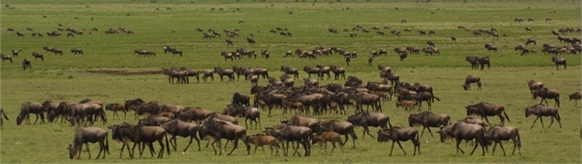
Fighting disease spread during ‘the greatest show on earth’(图)
Fighting disease ‘the greatest show on earth’
2010/2/24
The annual migration of over a million wildebeest across the Serengeti and Maasai Mara is often described as one of the greatest spectacles on earth. However, this natural wonder poses a real threat t...
Calcium Helps Evaluate Soil's Ability to Retain Earth's Carbon
Calcium Soil's Ability Earth's Carbon
2009/12/16
Soils play a vital role in dealing with the environmental impacts of rising atmospheric carbon levels, primarily CO2, from natural and human activities. The Earth's carbon budget is a dynamic process....
Characteristics of Heavy Rainfall by Typhoon 9709 in the Northern Part of Yamaguchi Prefecture and Rice Damage with Accumulation of Earth and Sand by Bank Collapse of Farm Pond
Accumulation of earth and sand Bank collapse of farm pond Heavy rainfall Northern part of Yamaguchi Prefecture
2009/7/21
Agricultural damage was caused by heavy rainfall during typhoon 9709 in the northern part of Yamaguchi Prefecture and the western part of Shimane Prefecture.In Mutsumi village, the amount of precipita...
Google Earth 是一个卫星影像浏览软件,它采用“虚拟地球”的方式,提供多种分辨率的全球影像数据。自05年问世以来,它的使用群体越来越多,在许多应用领域中都可以把它作为一个工具软件和开发平台。本文通过面向对象的编程语言,探讨了基于Google Earth的二次开发构造的具体步骤与方法,为利用Google Earth来构建农场GIS系统提出了一种新的思路与方法。