搜索结果: 1-15 共查到“工学 h/d ratio”相关记录84条 . 查询时间(0.046 秒)

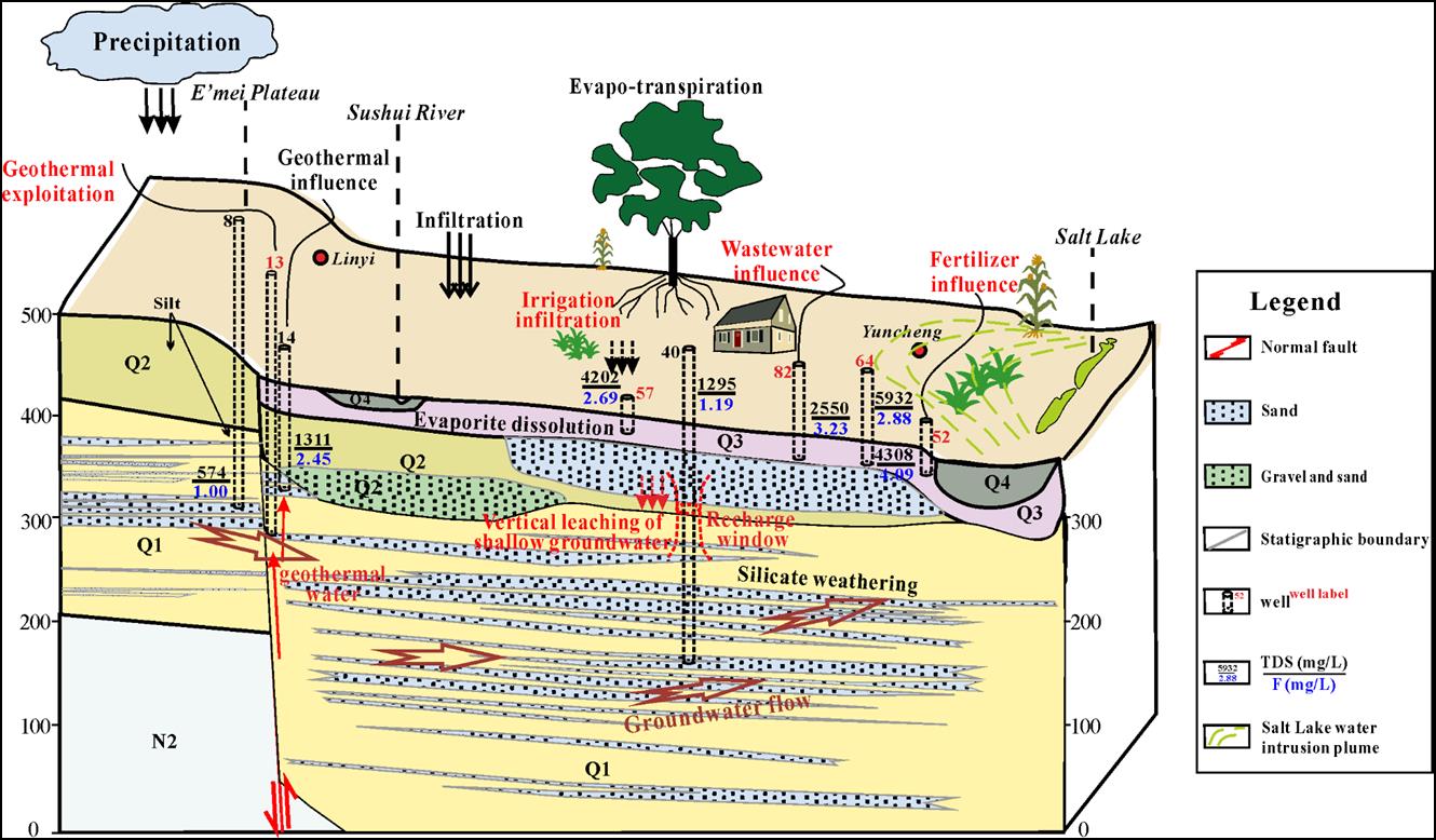
中国地质大学科学技术发展院李成城, 高旭波*等, 环境学院. Journal of Hydrology(2019), Impact of anthropogenic activities on the enrichment of fluoride and salinity in groundwater in the Yuncheng Basin constrained by Cl/Br ratio, δ18O, δ2H, δ13C and δ7Li isotopes(图)
人类;活动;影响;地下水;氟富集;领域;研究工作
2021/10/20
近日,中国地质大学环境学院高旭波副教授团队在人类活动影响地下水氟富集领域的研究工作取得重要进展。相关研究成果发表在国际著名期刊《Journal of Hydrology》和《Environmental Pollution》。上述研究成果为深入认识饮用地下水氟富集和氟的水文-生物地球化学循环机制提供了重要理论支撑与新思路。论文第一作者李成城,为环境学院博士后,师从王焰新教授,高旭波副教授为通讯作者。
OPTIMAL BAND RATIO ANALYSIS OF WORLDVIEW-3 IMAGERY FOR BATHYMETRY OF SHALLOW RIVERS (CASE STUDY:SARCA RIVER,ITALY)
Bathymetry River Optimal Band Ratio Analysis WorldView-3 GeoEye Spectral Bands
2016/11/30
The Optimal Band Ratio Analysis (OBRA) could be considered as an efficient technique for bathymetry from optical imagery due to its robustness on substrate variability. This point receives more attent...
RESEARCH ON FALSE COLOR IMAGE COMPOSITE AND ENHANCEMENT METHODS BASED ON RATIO IMAGES
Remote Sensing image Ratio Image False Color Image Composite Method Texture Analysis Sliding Window Method the Optimal Scale OIF method
2015/12/31
By referencing rock spectrum reflection curves, the effective bands of remote sensing images are selected which are treated with ratio processing in this paper. False color composition is proceeded by...
RATIO IMAGE PROCESSING TECHNIQUES:A PROSPECTING TOOL FOR MINERAL DEPOSITS,RED SEA HILLS,NE SUDAN
Landsat multispectral ratio images Red Sea Sudan
2015/12/29
The Red Sea Hills Region is a vast span of rugged, harsh and inhospitable sector of the Earth with inimical moon-like terrain, nevertheless since ancient times it is famed to be an abode of gold and w...
Side Ratio Constrain Based Precise Boundary Tracing Algorithm for Discrete Point Clouds
Laser Scanning (LiDAR) Edge detection Aerial Photogrammetry Feature Extraction
2015/12/8
Boundary tracing of discrete points is an important step to building model reconstruction using LiDAR data, its result directly effects the location regularization of building corners and the reconstr...
The Research and Design of the Base-height Ratio for the Three Linear Array Camera of Satellite Photogrammetry
Three linear Array CCD camera Satellite photogrammetry Space intersection angle
2015/11/23
In the satellite photogrammetry, the base-height ratio greatly impacts the elevation accuracy of the targets for the plotting map, and the greater base-height ratio, the higher elevation precision. Th...
"atmospheric" correction of digital colour images based on luminance ratio consideration
Photogrammetry Digital Technology Colour Imagery Atmosphere Correction
2015/9/1
Colour images change their appearance with increasing flying height: they are affected by an increasing bluish tint. This phenomenon is primarily the result of Rayleigh scattering. Considerations conc...
Flutter Suppression for High Aspect Ratio Flexible Wings Using Microflaps
Wings Using Microfl aps Microflaps
2015/6/18
Miniature trailing edge effectors (MiTEs) are small
flaps (typically 1% to 5% chord) actuated with deflection angles up to 90 degrees. Because of their
small size, these devices pr...

A new Duke theory identifies the height-to-base ratio that helped humanity master fire and migrate across the globe(图)
Duke theory identifies height-to-base ratio helped humanity master fire migrate across the globe
2015/6/18
In a study published in Nature Scientific Reports on June 8, 2015, Adrian Bejan, the J.A. Jones Professor of Mechanical Engineering at Duke University, shows that, all other variables being equal, the...
The Novice-Expert ratio Method (NEM) compares the time it takes a novice user to complete each step of a task with the time it takes an expert user to complete the same step. A high ratio indicates th...
EXPLORING THE RELATIONSHIPS BETWEEN LAND SURFACE TEMPERATURE, GROUND COVERAGE RATIO AND BUILDING VOLUME DENSITY IN AN URBANIZED ENVRONMENT
Land surface temperature Ground coverage ratio
2015/5/6
The objective of this study is to explore and compare the relationships between urban land surface temperature (LST), ground coverage ratio (GCR) and building volume density (BVD). Landsat ETM+ data...
SHADOW DETECTION FROM VERY HIGH RESOLUTON SATELLITE IMAGE USING GRABCUT SEGMENTATION AND RATIO-BAND ALGORITHMS
VHR Satellite Imagery Shadow Detection Shadow Context Image Segmentation Grab Cut partitioning Urban Area WorldView-3
2015/4/1
Very-High-Resolution (VHR) satellite imagery is a powerful source of data for detecting and extracting information about urban constructions. Shadow in the VHR satellite imageries provides vital infor...
DEVELOPMENT OF REAL TIME 3-D MEASUREMENT SYSTEM USING INTENSITY RATIO METHOD
Vision Sciences Vision Measurement
2015/3/24
Previously, we developed a real time 3-D measurement system based on slit-ray projection method, which enables us
to obtain serial range images at 1/30 seconds per scene with an error within ±0.3%. I...
Reducing peak to average power ratio of OFDM by using selected mapping
High speed data transmission transmitter rf power amplifier mapping
2014/12/31
Orthogonal frequency division multiplexing (OFDM) has become the most popular modulation technique for high speed data transmission. However, high peak to average power ratio (PAPR) is a major drawbac...
Landslide susceptibility mapping by combining the three methods Fuzzy Logic, Frequency Ratio and Analytical Hierarchy Process in Dozain basin
Landside susceptibility Fuzzy Analytical Hierarchy Process frequency ratio
2014/12/1
Landslides are among the most important natural hazards that lead to modification of the environment. Therefore, studying of this phenomenon is so important in many areas. Because of the climate condi...

