搜索结果: 1-15 共查到“工学 Africa”相关记录90条 . 查询时间(0.125 秒)

A COMPARATIVE ANALYSIS OF FIVE CROPLAND DATASETS IN AFRICA
Africa Land cover Cropland area Spatial location Accuracy
2018/5/15
The food security, particularly in Africa, is a challenge to be resolved. The cropland area and spatial distribution obtained from remote sensing imagery are vital information. In this paper, accordin...
AN EXPLORATORY STUDY OF CIVIL SERVANTS SPATIAL THINKING, AWARENESS AND USE OF MAPS IN AFRICA-NIGERIA
Space Spatial thinking Map Civil servants Nigeria
2018/5/11
The paper is an exploratory study of spatial thinking, awareness and use of maps among civil servants in Nigeria with a view towards enhancing capacity building in the development and use of global ma...
2017 非洲研究创新与发展国际会议(EAI International Conference for Research, Innovation and Development for Africa)
2017 非洲研究 创新 发展 国际会议
2017/5/23
The Conference Theme is: "Moving Africa forward through Engineering, Technology and Innovation". The conference seeks to bring together academics, researchers and industrialists across many discipline...
USING REMOTE SENSING AND GIS TECHNIQUES TO DETECT CHANGES TO THE PRINCE ALFRED HAMLET CONSERVATION AREA IN THE WESTERN CAPE,SOUTH AFRICA
Change Detection Remote Sensing Biodiversity Wetland Conservation
2016/11/23
Understanding and identifying the spatial-temporal changes in the natural environment is crucial for monitoring and evaluating conservation efforts, as well as understanding the impact of human activi...
MOBILE GIS: A TOOL FOR INFORMAL SETTLEMENT OCCUPANCY AUDIT TO IMPROVE INTEGRATED HUMAN SETTLEMENT IMPLEMENTATION IN EKURHULENI, SOUTH AFRICA
Mobile GIS occupancy audit informal settlements
2016/7/8
Upgrading and relocating people in informal settlements requires consistent commitment, good strategies and systems so as to improve the lives of those who live in them. In South Africa, in order to a...
INVESTIGATING THE USE OF 3D GEOVISUALIZATIONS FOR URBAN DESIGN IN INFORMAL SETTLEMENT UPGRADING IN SOUTH AFRICA
urban design map reading geovisualization
2016/7/8
Informal settlements are a common occurrence in South Africa, and to improve in-situ circumstances of communities living in informal settlements, upgrades and urban design processes are necessary. Spa...
The Africa Task Force
Africa Task Force
2016/1/22
The aim of this publication is to present the objective and work design of the FIG Africa Task Force (ATF), identify the interlinking themes, summarise the contents and outcome of each workshop and ma...

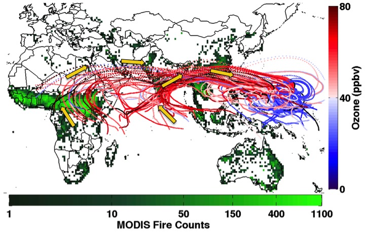
Fires Burning in Africa & Asia Cause High Ozone in Tropical Pacific(图)
Fires Burning Africa Asia High Ozone Tropical Pacific
2016/1/22
While efforts to limit ozone precursor emissions tend to focus on industrial activities and fossil fuel combustion in the United States and China, a new University of Maryland-led study suggests that ...
VEGETATION DYNAMICAL PATTERNS RELATED TO RAINFALL VARIABILITY ANALYSED WITH WAVELET COHERENCY FOR SOUTHERN AFRICA
Multi-spectral remote sensing Change detection Environmental monitoring Image interpretation Spatial-temporal Analysis wavelet transformation
2015/12/31
This study contributes to a better understanding of the spatial and temporal patterns of ecosystem dynamics in Southern Africa in response to climatic variability. First, we identified the areas where...
1979-1999 satellite total ozone column measurements over West Africa
ozone aerosol lidar satellite QBO
2015/9/28
Total Ozone Mapping Spectrometer (TOMS) instruments have been flown on NASA/GSFC satellites for over 20 years. They provide near real-time ozone data for Atmospheric Science Research. As part of preli...
Use of remote sensing in support of crop area estimates in South Africa
Satellite Imagery Crop Area Estimates Aerial Survey
2015/9/6
In South Africa the National Department of Agriculture (DoA)
is the custodian of the Crop Estimates Committee (CEC) that is
responsible for the grain crop production estimates, published
monthly. T...
Mapping regions of high temporal variability in africa
Global Change Temporal Variability Land Characterization
2015/8/21
Long term observation of space-borne remote sensing data provides a means to explore temporal variation on the Earth’s surface.
This improved understanding of variability is required by numerous glob...
A FLOOD EARLY WARNING SYSTEM FOR SOUTHERN AFRICA
Flooding hydrological models the flood risk monitoring rainfall forced evapotranspiration remote sensing data
2015/5/13
Sizeable areas of the Southern African Region experienced widespread flooding in 2000. Deployment of hydrologic
models can help reduce the human and economic losses in the regions by providing impro...
Towards an automated monitoring of human settlements in South Africa using high resolution SPOT satellite imagery
Automated Image Information Extraction Settlement Mapping
2015/5/7
Urban areas in sub-Saharan Africa are growing at an unprecedented pace. Much of this growth is taking place in informal settlements. In South Africa more than 10% of the population live in urban inf...


