
�������: 1-15 ���鵽��Satellite����ؼ�¼1216�� . ��ѯʱ��(0.091 ��)
Grouping-Based Time-Series Model for Monitoring of Fall Peak Coloration Dates Using Satellite Remote Sensing Data
phenology monitoring fall foliage coloration grouping-based time-series analysis spatial and temporal scale optical remote sensing
2024/1/12
Accurate monitoring of plant phenology is vital to effective understanding and prediction of the response of vegetation ecosystems to climate change. Satellite remote sensing is extensively employed t...
Monitoring Three-Decade Expansion of China's Major Cities Based on Satellite Remote Sensing Images
urbanization satellite remote sensing urban expansion trajectories urban village north-south differentiation
2024/1/12
As the largest developing country, China has experienced dramatic urban expansion since the "reform and opening-up" policy started at the end of the 1970s. In this paper, we monitor three decades of u...
Monitoring hourly night-time light by an unmanned aerial vehicle and its implications to satellite remote sensing
Night-time light Unmanned aerial vehicle Hourly dynamic Urban function Spectral analysis
2023/12/21
Satellite-observed night-time light in urban areas has been widely used as an indicator for socioeconomic development and light pollution. Up to present, the diurnal dynamics of city light during the ...
Astrape: A System for Mapping Severe Abiotic Forest Disturbances Using High Spatial Resolution Satellite Imagery and Unsupervised Classification
astrapeforest disturbanceSentinel-2planetdoveimage segmentation RSGISLibjenksXGBoost
2023/12/6
Severe forest disturbance events are becoming more common due to climate change and many forest managers rely heavily upon airborne surveys to map damage. However, when the damage is extensive, airbor...
Synthesizing Disparate LiDAR and Satellite Datasets through Deep Learning to Generate Wall-to-Wall Regional Inventories for the Complex, Mixed-Species Forests of the Eastern United States
LiDAR airborne laser scanning enhanced forest inventory aboveground biomass forest carbon deep learning Maine New Hampshire Vermont Massachusetts Connecticut Rhode Island
2023/12/5
Light detection and ranging (LiDAR) has become a commonly-used tool for generating remotely-sensed forest inventories. However, LiDAR-derived forest inventories have remained uncommon at a regional sc...
Satellite�CDerived Topography and Morphometry for VHR Coastal Habitat Mapping: The Pleiades�C1 Tri�CStereo Enhancement
leiades�C1 photogrammetry RSP topography classification maximum likelihood landscape
2023/12/4
The evolution of the coastal fringe is closely linked to the impact of climate change, specifically increases in sea level and storm intensity. The anthropic pressure that is inflicted on these fragil...
Tropical Forest Disturbance Monitoring Based on Multi-Source Time Series Satellite Images and the LandTrendr Algorithm
Hainan Island forest disturbances LandTrendr Google Earth engine
2023/11/22
Monitoring disturbances in tropical forests is important for assessing disturbance-related greenhouse gas emissions and the ability of forests to sequester carbon, and for formulating strategies for s...
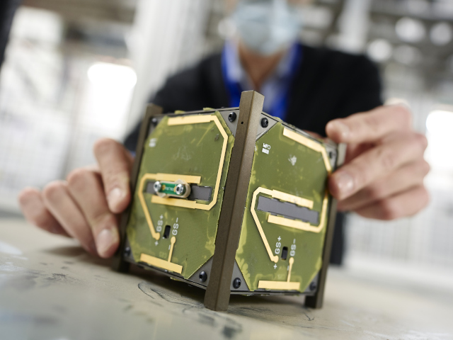
On 13 July, CELESTA will be launched into space: this microsatellite is the first space mission driven by CERN, in collaboration with the University of Montpellier and the European Space Agency (ESA).
A new program provides undergraduates, graduate students and postdoctoral researchers from the College of Engineering and the College of Arts and Sciences with hands-on experience in developing innova...
Global satellite data shows clouds will amplify global heating
cloud global heating satellite measurements
2021/8/3
A new approach to analyse satellite measurements of Earth's cloud cover reveals that clouds are very likely to enhance global heating.
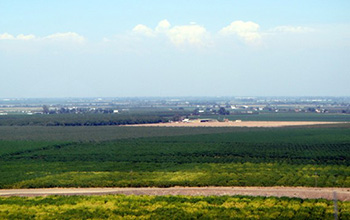
Researchers use satellite imaging to map groundwater use in California's Central Valley��ͼ��
satellite imaging map groundwater California Central Valley
2020/10/16
Researchers at the University of California, San Diego report a new way to improve groundwater monitoring by using a remote sensing technology, known as InSAR (interferometric synthetic aper...

Satellite constellations harvest energy for near-total global coverage��ͼ��
Satelliteconstellations harvest energy global coverage
2020/1/19
Think of it as a celestial parlor game: What is the minimum number of satellites needed to see every point on Earth? And how might those satellites stay in orbit and maintain 24/7 coverage while conte...
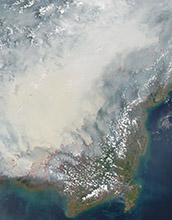
Satellite data can reveal fire susceptibility in peatlands��ͼ��
Satellite data fire susceptibility peatlands
2019/10/18
When large areas of carbon-rich soil catch fire, the blaze emits massive amounts of carbon into the atmosphere and creates a thick haze. These blazes can usher in long-term climate impacts that affect...
CLASSIFICATION OF THE STRUCTURE OF CITIES THROUGH MID-RESOLUTION SATELLITE IMAGERY AND PATCH BASED NEURAL NETWORKS
Convolutional Neural Networks (CNN) Autoencoders Sentinel 2B Indian Cities
2019/2/28
The studies in the classification of the urban spatial structure have been essential in deriving insights into the land cover and the built typology which helped in the estimation of energy consumptio...
EXTRACTION OF BLUE ICE AREA USING ALBEDO VALUE DERIVED FROM LANDSAT-8 SATELLITE DATA
Blue Ice Landsat-8 Albedo Polar record Glacier Image Processing
2019/2/28
Blue Ice Areas (BIAs) or bare ice areas are zones of glacier where surface mass balance is negative, sublimation forms the major ablation process and surface albedo is relatively small. Exceptionally ...
�й��о����������а�-��
- ���ڼ���...
�й�ѧ���ڿ����а�-��
- ���ڼ���...
�����ѧ���л������а�-��
- ���ڼ���...
�й���ѧ���а�-��
- ���ڼ���...
�ˡ���-ƪ
- ���ڼ���...
�Ρ���-ƪ
- ���ڼ���...
��������-ƪ
- ���ڼ���...
�������� -ƪ
- ���ڼ���...
֪ʶҪ��-ƪ
- ���ڼ���...
���ʶ�̬-ƪ
- ���ڼ���...
��������-ƪ
- ���ڼ���...
ѧ��ָ��-ƪ
- ���ڼ���...
ѧ��վ��-ƪ
- ���ڼ���...