
搜索结果: 1-15 共查到“遥感信息工程 Environment”相关记录55条 . 查询时间(0.167 秒)
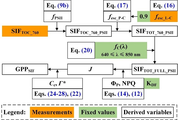
Remote Sensing of Environment刊发中国科学院水利部水土保持研究所吕肖良研究员团队日光诱导叶绿素荧光研究工作进展(图)
吕肖良 日光诱导 叶绿素荧光 SIF GPP
2022/6/8
近日,中国科学院水利部水土保持研究所吕肖良研究员团队以西北农林科技大学黄土高原土壤侵蚀与旱地农业国家重点实验室为第一单位在国际遥感领域顶级期刊Remote Sensing of Environment(G1期刊)发表了题为“Direct estimation of photosynthetic CO2 assimilation from solar-induced chlorophyll fluo...

同济大学测绘与地理信息学院王群明教授课题组本科生在遥感领域顶级期刊《Remote Sensing of Environment》发表论文:Blocks-removed spatial unmixing for downscaling MODIS images(图)
同济大学 测绘与地理信息学院 王群明 教授 课题组 遥感领域 顶级期刊
2021/3/18
近日,同济大学测绘与地理信息学院王群明教授课题组在遥感领域顶级期刊《Remote Sensing of Environment》发表了1篇论文。本研究受到国家自然基金项目(41971297)资助。
中国南极测绘研究中心庞小平教授团队海冰遥感研究成果在《Remote Sensing of Environment》发表
中国南极测绘研究中心 庞小平 教授 海冰遥感 研究成果 《Remote Sensing of Environment》
2020/9/7
通过更高分辨率的热红外影像,我们能发现北极海冰的哪些有趣特性?近日,我中心博士生范沛为第一作者,赵羲副教授为通讯作者的研究论文在《环境遥感》发表。该研究基于Landsat 8 TIRS热红外影像,验证了几种经典的温度反演算法在北极海冰区域的精度,并对冰间水道和海冰边缘带的温度特征进行了分析。
LANDSLIDE HAZARD ZONATION MAPPING OF CHAMOLI LANDSLIDES IN REMOTE SENSING AND GIS ENVIRONMENT
Landslides Chamoli Remote Sensing Hazard, Himalaya
2019/2/27
Landslides are very common problem in hilly terrain. Chamoli region of Himalaya is highest sensitive zone of the landslide hazards. The purpose of Chamoli landslide study, to observe the important ter...
PROCESSING BIG REMOTE SENSING DATA FOR FAST FLOOD DETECTION IN A DISTRIBUTED COMPUTING ENVIRONMENT
Distributed Computing Geospatial Big Data Cloud Computing Fast Flood detection Big Earth Observation Data
2017/8/10
The Earth observation (EO) missions of the space agencies and space industry (ESA, NASA, national and commercial companies) are evolving as never before. These missions aim to develop and launch next-...
MODELLING AND ACCURACY IN A BIM ENVIRONMENT FOR PLANNED CONSERVATION: THE APARTMENT OF TROIA OF GIULIO ROMANO
BIM, accuracy 3D modelling HBIM planned conservation
2017/4/5
Modeling of Cultural Heritage in a BIM environment, and in general of existing buildings, requires special attention because there are two diametrically opposed possibilities. On the one hand the atte...
MAPPING OF CORAL REEF ENVIRONMENT IN THE ARABIAN GULF USING MULTISPECTRAL REMOTE SENSING
Mapping Coral Reef Benthic Habitats DubaiSat-2 Arabian Gulf
2016/12/1
Coral reefs of the Arabian Gulf are subject to several pressures, thus requiring conservation actions. Well-designed conservation plans involve efficient mapping and monitoring systems. Satellite remo...
COMPREHENSIVE EVALUATION OF URBAN SPRAWL ON ECOLOGICAL ENVIRONMENT USING MULTI-SOURCE DATA:A CASE STUDY OF BEIJING
Urban sprawl Ecological environment Beijing Multi-source data Multiscale
2016/12/1
With urban population growing and urban sprawling, urban ecological environment problems appear. Study on spatiotemporal characteristics of urban sprawl and its impact on ecological environment is use...
ACCURACY ASSESSMENT OF MOBILE MAPPING POINT CLOUDS USING THE EXISTING ENVIRONMENT AS TERRESTRIAL REFERENCE
Accuracy Assessment Mobile Mapping Point Cloud Reference Data Total Station 3D Test Field Facades Street profile
2016/7/5
Mobile mapping data is widely used in various applications, what makes it especially important for data users to get a statistically verified quality statement on the geometric accuracy of the acquire...
APPLICATIONS OF THE RESOURCE SATELLITES FOR ENVIRONMENT AND DISASTER MONITORING AND FORECASTING IN DISASTER MONITORNG AND ASSESSMENT
The Resource Satellites constellation the Resource Satellites disaster monitoring assessment
2016/3/17
The Satellite Constellation for Environment and Disaster Monitoring and Forecasting is a new generation of in-building remote sensing constellation. Just as the name, the new constellation was especia...
APPLICAIONTS OF SMALL SATELLITE CONSTELLATION FOR ENVIRONMENT AND DISASTER MONITORING AND FORCASTING (SSCEDMF) IN DISASTER MONITORNG AND ASSESSMENT
remote sensing applications small satellite constellation HJ-1 disaster monitoring disaster assessment
2016/3/17
SSCEDMF is a new generation of in-building remote sensing constellation. Just as the name, the new constellation was especially designed for the environment and disaster monitoring andforecasting. And...
CHINA RESOURCES AND ENVIRONMENT REMOTE SENSING SATELLITES’ APPLICATION IN MONITORING BUSHFIRE IN VICTORIA IN AUSTRALIA
Bushfire Monitoring Application Victoria in Australia China Resources and Environment Remote Sensing Satellites
2016/3/17
The utilization of remote sensing satellite data for fire monitoring has been more than a decade, and currently mainly relies on the EOS/ MODIS satellite series. MODIS has specialized thermal infrared...
RETRIEVING LST AND ITS THERMAL ENVIRONMENT EVALUATION ANALYSIS BASED ON CBERS-02 IRMSS AND MODIS DATA
CBERS-02 IRMSS Land Surface Temperature (LST) Atmospheric Water Vapour Content Human Body Comfort Index Thermal Environment Evaluation
2016/3/17
The thermal environment and thermal effect is one of the most important contents in city climate and environment researches.Retrieving and analyzing land surface temperature (LST) is an efficient way ...
RESEARCH ON SPATIAL-TEMPORAL CHANGE OF URBAN THERMAL ENVIRONMENT BASED ON REMOTE SENSING
Urban Remote Sensing Change Thermal Environment Spatial-Temporal Research
2015/12/31
Appling remote sensing technology to monitor urban thermal environment change, can reveal the spatail-temporal change process and discover the important regions of urban thermodynamic field distributi...
ANALYSIS OF THE EFFECTIVENESS OF SPECTRAL MIXTURE ANALYSIS AND MARKOV RANDOM FIELD BASED SUPER RESOLUTION MAPPING OVER AN URBAN ENVIRONMENT
Hyperspectral Images Spectral Mixture Analysis Markov Random Field Simulated annealing Super Resolution Mapping
2015/12/31
The information in a pixel of satellite data within the instantaneous Field of View (IFOV) of the sensor is a mixture of different land cover types, and the individual land cover components can be est...