搜索结果: 1-15 共查到“工学 Feature”相关记录238条 . 查询时间(0.078 秒)
Modulation of interfacial interactions toward strong and tough cellulose nanofiber-based transparent thin films with antifogging feature
Cellulose nanofiber Transparent film Cross-linker Flexibility Toughness Antifogging
2023/12/1
Cross-linking is often performed to overcome the weak mechanical properties of native polymer films in order to expand their functional properties and applications. While this approach offers enhanced...

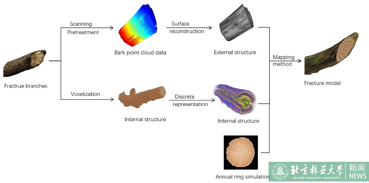
2023年6月28日,《Forests》(中科院期刊分区表大类二区,IF=3.282)刊发了2023年最新一期(Volume 14, Issue 5)的文章,我校信息学院杨猛课题组论文《Visualization Simulation of Branch Fractures Based on Internal Structure Reconstruction》被选为本期的“Feature Pape...
ON THE ESTIMATION OF POLARIMETRIC PARAMETERS FOR OIL SLICK FEATURE DETECTION FROM HYBRID POL AND DERIVED PSEUDO QUAD POL SAR DATA
SAR RISAT-1 CTLR pseudo-quad pol correlation coefficient sigma naught
2019/2/28
Oil spills in oceans have a significant long term effect on the marine ecosystem and are of prime concern for maritime economy. In order to locate and estimate the oil spread area and for quantitative...
UAV PHOTOGRAMMETRY FOR FEATURE EXTRACTION AND MAPPING OF CORRUGATED INDUSTRIAL ROOFTOPS
photogrammetry UAV, drones solar panel point cloud corrugated roof
2018/11/9
Corrugated roof sheets used for large-scale industrial rooftops have the potential to carry solar panels. The sheets, however, need to be surveyed so that the solar panels can be installed according t...
ABOVEGROUND BIOMASS ESTIMATION USING RECONSTRUCTED FEATURE OF AIRBORNE DISCRETE-RETURN LIDAR BY AUTO-ENCODER NEURAL NETWORK
Aboveground Biomass (AGB) Estimation Discrete-Return LiDAR Regression Auto-Encoder Neural Network
2018/5/14
Aboveground biomass (AGB) estimation is critical for quantifying carbon stocks and essential for evaluating carbon cycle. In recent years, airborne LiDAR shows its great ability for highly-precision A...
A STATISTICAL TEXTURE FEATURE FOR BUILDING COLLAPSE INFORMATION EXTRACTION OF SAR IMAGE
Synthetic Aperture Radar (SAR), Building Collapse Information, Texture, G0 Distribution, Texture Parameter
2018/5/14
Synthetic Aperture Radar (SAR) has become one of the most important ways to extract post-disaster collapsed building information, due to its extreme versatility and almost all-weather, day-and-night w...
DATUM FEATURE EXTRACTION AND DEFORMATION ANALYSIS METHOD BASED ON NORMAL VECTOR OF POINT CLOUD
Deformation Analysis Point Cloud Normal Vecto Datum Feature Cubic B-spline Curve
2018/5/15
In order to solve the problem lacking applicable analysis method in the application of three-dimensional laser scanning technology to the field of deformation monitoring, an efficient method extractin...
EARTHQUAKE BUILDING DAMAGE MAPPING BASED ON FEATURE ANALYZING METHOD FROM SYNTHETIC APERTURE RADAR DATA
Building Damage Assessment Earthquake Emergency Feature Analysing SAR
2018/5/11
Playing an important role in gathering information of social infrastructure damage, Synthetic Aperture Radar (SAR) remote sensing is a useful tool for monitoring earthquake disasters. With the wide ap...
RESEARCH ON REMOTE SENSING IMAGE CLASSIFICATION BASED ON FEATURE LEVEL FUSION
Remote sensing image fusion Remote sensing image classification Feature level Sentinel-1A Landsat8 OLI
2018/5/16
Remote sensing image classification, as an important direction of remote sensing image processing and application, has been widely studied. However, in the process of existing classification algorithm...
ROBUST FEATURE MATCHING IN TERRESTRIAL IMAGE SEQUENCES
Feature Detection Feature Matching SIFT SURF RANSAC 3D Reconstruction
2018/5/11
From the last decade, the feature detection, description and matching techniques are most commonly exploited in various photogrammetric and computer vision applications, which includes: 3D reconstruct...
PURIFICATION OF TRAINING SAMPLES BASED ON SPECTRAL FEATURE AND SUPERPIXEL SEGMENTATION
Beijing-2 Satellite imagery Training Samples Purification Spectral Feature Superpixel Segmentation
2018/5/14
Remote sensing image classification is an effective way to extract information from large volumes of high-spatial resolution remote sensing images. Generally, supervised image classification relies on...
BUILDING FACADE MODELING UNDER LINE FEATURE CONSTRAINT BASED ON CLOSE-RANGE IMAGES
Close-range Image Line Feature Building Modeling
2018/5/15
To solve existing problems in modeling facade of building merely with point feature based on close-range images , a new method for modeling building facade under line feature constraint is proposed in...
ARCHAEOLOGICAL FEATURE DETECTION FROM ARCHIVE AERIAL PHOTOGRAPHY WITH A SFM-MVS AND IMAGE ENHANCEMENT PIPELINE
Archaeology feature detection SfM-MVS image enhancement cultural heritage
2018/6/4
Understanding and protecting cultural heritage involves the detection and long-term documentation of archaeological remains alongside the spatio-temporal analysis of their landscape evolution. Archive...
FEATURE MATCHING OF HISTORICAL IMAGES BASED ON GEOMETRY OF QUADRILATERALS
historical images image orientation feature matching descriptor matching quadrilaterals geometry
2018/6/4
This contribution shows an approach to match historical images from the photo library of the Saxon State and University Library Dresden (SLUB) in the context of a historical three-dimensional city mod...
A DETECTION METHOD OF ARTIFICIAL AREA FROM HIGH RESOLUTION REMOTE SENSING IMAGES BASED ON MULTI SCALE AND MULTI FEATURE FUSION
Artificial Areas Automatic Detection Geometric Features Visual Saliency Features Multi Scale Feature Fusion
2017/7/12
In order to solve the problem of automatic detection of artificial objects in high resolution remote sensing images, a method for detection of artificial areas in high resolution remote sensing images...

